The Dos Luis Project is moving forward to a new public hearing following the expansion of its area of interest. The companies driving the plan, covering 234,000 hectares, expect to begin geophysical work between December and January, pending environmental approval.
By Panorama Minero
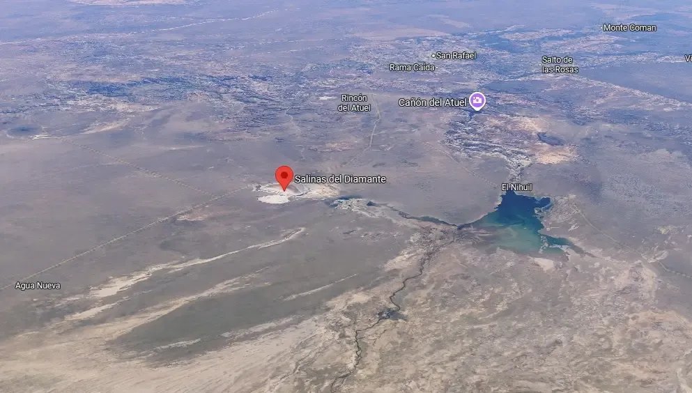
Ampere Lithium and El Jarillar S.A. are spearheading an ambitious exploration initiative in southern Mendoza. The project aims to gather data on the lithium brine and other mineral potential of the Salinas del Diamante area. The zone of interest covers a surface of 234,256.5 hectares within the San Rafael and Malargüe departments.
In this context, the Government of Mendoza announced a new public hearing for the lithium exploration project “Don Luis & Other.” The project has expanded its area of influence toward the Malargüe department, adding to its original coverage in San Rafael. The hearing will take place on Saturday, November 29, at 9 a.m.
The call responds to the project’s territorial expansion, which incorporates new mining properties and modifies the direct area of influence of its activities.
Eduardo Piñero, President of Ampere Lithium, outlined the timeline for the initial exploration campaign and explained the scope of the Don Luis Project’s territorial expansion, which seeks crucial subsurface data to advance toward potential future resource development.
Exploration Stages
Piñero detailed the initial exploration schedule, which depends on administrative approval. The company expects to begin activities later this year, subject to obtaining the Environmental Impact Declaration (EID). Piñero stated, “If we obtain the EID in early December, the idea is to start the geophysical surveys between December and January.”
“We’ll start with geophysics, conducting soil and subsurface surveys while always taking flora, fauna, and the environment into account,” Piñero explained.
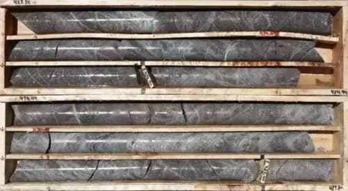
Once this initial phase is completed, the company plans to move into the drilling stage. The Ampere Lithium executive added that he expects “to receive approval for well locations by February or March and begin drilling shortly after.” If the results prove promising, the project will advance to a second phase involving five drill holes ranging from 90 to 600 meters in depth.
The company is now organizing a new public hearing due to the project’s territorial expansion. “We acquired 23 additional properties, so we took the opportunity to extend the entire project — Don Luis & Others,” Piñero noted.
Ampere indicated that the exploration aims to identify both concentration and volume of lithium resources.
Direct Extraction Approach
The project follows a low-impact model designed to minimize environmental risks. Piñero assured that, should exploration prove successful, the company plans to develop a project using the Direct Lithium Extraction (DLE) process. “The process will be carried out in a plant using filters, avoiding the use of evaporation ponds. DLE will deliver a far more positive and lower environmental impact,” he said.
Technical Summary
Mining Properties
-
Proponents: Consortium formed by El Jarillar S.A., Eduardo Piñero, and Cordillera Ventures S.A. (CVSA).
-
Total Area: 234,256.5 hectares.
-
Mining Files: 26 mining claims, including Salinas del Diamante Norte, Oeste, Sur (Holder: Eduardo Eugenio Piñero) and Don Luis I, II, III (Holder: El Jarillar S.A.).
-
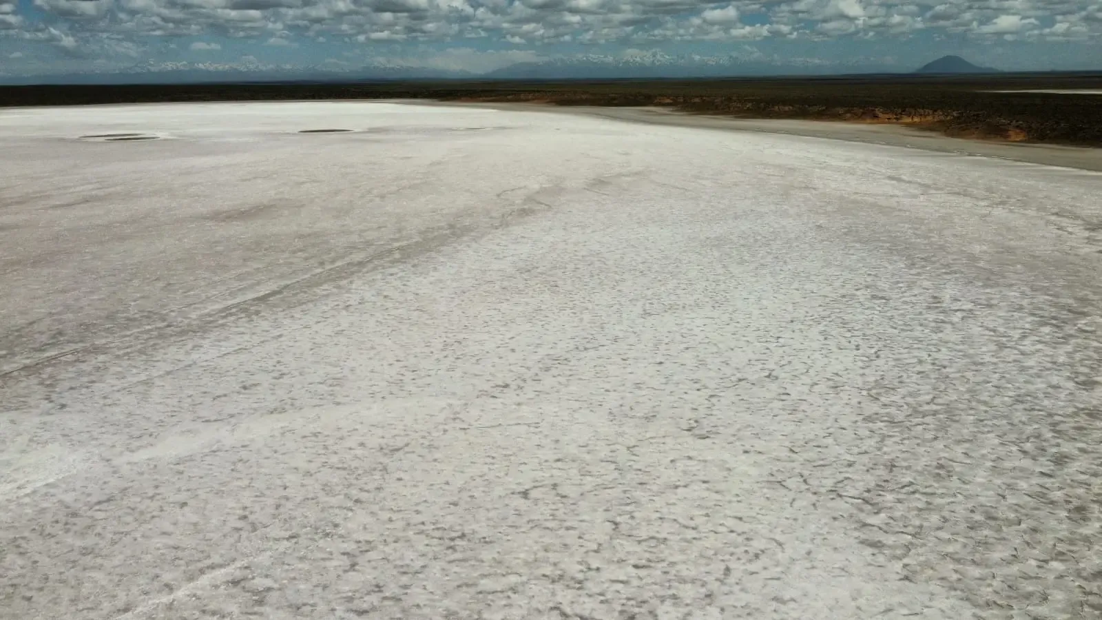
Existing Use: El Jarillar S.A. currently exploits Salinas del Diamante for surface salt extraction.
-
Geomorphology: Closed endorheic basin where sedimentary deposits accumulate through salt precipitation and evaporation.
-
Surface Lithology: The salt crust is composed mainly of halite (Sodium Chloride, NaCl).
-
Hydrogeology: The area lies on the QS Unit (Quaternary sediments hosting aquifers). Groundwater depth ranges between 10 and 40 meters near Malargüe.
-
Climate: Predominantly dry, classified as desert (Bwk) and semi-arid (Bsk) with cold winters. Average Annual Precipitation: 274.3 mm (1993–2023).
Exploration Methodology (Two Phases)
Phase 2 is contingent on satisfactory Phase 1 results.
- Phase 1: Geological Mapping and Geophysics
-
Geological Mapping: Visual reconnaissance using 4x4 vehicles along existing roads to map surface features and georeference pre-existing oil wells.
-
Geophysical Technique: Magnetotelluric surveys to measure subsurface resistivity.
-
Design: Readings every 1,000 meters.
-
Reading Duration: 5–10 minutes per station.
-
Estimated Readings: Between 30 and 50 measurements.
-
Personnel Required: 3 people (driver, geologist, and assistant).
- Phase 2: Drilling Program
-
Estimated Depth: Between 90 and 600 meters.
-
Objective: To obtain lithological data (via core samples) and measure hydrogeological parameters such as transmissivity, porosity, and brine permeability.
Drilling Methods:
-
Reverse Circulation (RC): Uses compressed air with reverse circulation; no water required.
-
Diamond Drilling (DDH): Employs industrial diamond bits; requires water with additives for cooling.
On-Site Operations:
-
Platform Size: Each drill pad will occupy between 625 m² (25 × 25 m) and 900 m² (30 × 30 m).
-
Pumping Tests: Brine extraction for up to 72 hours to measure physico-chemical parameters.